There's been a lot of good coverage of Dutch cycling infrastructure in British media lately, which I find encouraging! The most recent article I enjoyed was The Guardian's history of Groningen's revolutionary re-engineering in the 1970s. While it characterises the move as "anti-car", perhaps suggesting erroneously that the benefits for cycling were accidental, the picture it paints contains a key element for how we need to think about roads.
Cars Were Not Banned
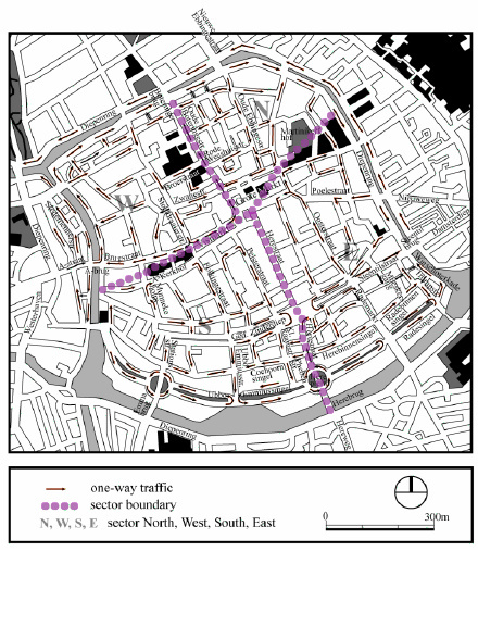
The image above is from a Swedish paper about the Van den Berg plan. In it they say (emphasis mine):
The major aim of this plan was to make the downtown area and especially the old town more livable and accessible for traffic participators both users of public transportation and private cars.
The map gives a hint to the original 1977 plan: arrows describe a new system of one-way roads, and dotted lines show "sector boundaries" which automobiles were not allowed to cross. But note that this does not mean automobiles were not allowed into those sectors! Motorcar drivers were permitted to head out to the higher-capacity ring road to travel from one sector to another.
On foot or by bicycle, this circuitous path would be a hardship. But a motorcar doesn't tire out for having to take a slight detour, and in fact the ride is more comfortable on the higher-capacity road where greater speed is possible. So it would seem that instead of being some kind of ideological anti-car revolution, this was just sensible road design, no?
Sharing the wrong Space
London has recently begun to feel the pressure from its citizens to provide the kind of infrastructure that is commonplace in the Netherlands. As can be expected, the first few attempts were token projects that were all decoration with no material improvement. The poster child for this problem is the Exhibition Road "Shared Space" resurfacing in South Kensington. As Mark Treasure explains, this was entirely the wrong sort of road to receive this treatment!
One can forgive the inexperienced planning contractors who worked on this for saying "Well, there's pedestrians who want to get between the museums here, and cars that want to go through here, so why don't we try this fancy surface to hint to everyone that pedestrians have the right to use this space?" It appealed to me, when I first saw it on a weekend; after all, I'd regularly seen families looking furtively around and pushing buggies across the middle of the road to get to the V&A from the Science Museum!
Destinations vs. Thoroughfares
But the key problem is that for the pedestrians this road is a destination, while for the motorcars it is a thoroughfare. We ignore this distinction at our peril!
What London has done is to apply methods used on Dutch access roads to a through road. It's as if they couldn't tell the difference between a car park and a motorway, and from what I've seen of road policy in this country even that distinction may have little weight.
"Why do you hate business?"
Whenever a public hearing is held about a new scheme to reduce the speed of a road or add cycle infrastructure, invariably someone claims that the shopkeepers hate it because the reduction in traffic will result in a loss of business. It's been debunked time and again in country after country: cars speeding past your shop do not spend their money with you, but people on foot, mobility scooters, bicycles and tricycles do.
What these shopkeepers may be worried about is that some nefarious "anti-car" policy will hurt their status as a destination for motorists. That they can't see the harm that being on a smooth thoroughfare does to them is a sign of how badly we talk about roads. Shopping areas in the Groningen plan are still motoring destinations, and if anything the shopkeepers can be more confident that the motorists in the area are actually spending money!
Open Roads and Flowerpot Junctions
But as we've seen with the Waltham Forest Mini Holland scheme, the bikelash can be vicious. Outside agitators will drive their Chelsea Tractors in from miles away to protest the loss of a single sneaky rat-run.
The anti #MiniHolland brigade. No wonder they're against it. Lots of 'em didn't even know why they were there. pic.twitter.com/SriMwEGkcW
— Mousey (@MouseyRussell) October 22, 2015There are two big confusions the bikelash brigade seem to have. The first is the matter of which part of Berlin was surrounded by the Berlin Wall:
Bike paths are just like the Berlin Wall say pro-car-parking protesters at today's Walthamstow #miniholland launch. pic.twitter.com/cUK69fwyIL
— Carlton Reid (@carltonreid) September 14, 2015The second is that they actually think these roads have been closed! And who can blame them, given maps like these:
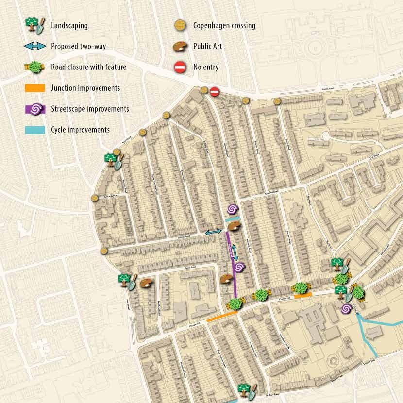
They've put some flowerpots on specific parts of a few junctions, but the legend calls it a "Road closure with feature".
Take a look at those roads. Trace your finger along them, and try to find a space on any road shown that cannot be driven to or from.
Do you see the problem? They're telling the public that roads will be closed, but the clear and obvious fact is that these roads will remain open. And this isn't some equivocating cycling-first agenda here: automobiles and ambulances and fire engines and delivery vans will still be able to drive to and from the buildings on those roads.
Language is Important
We need to act quickly on this, and get all the local authorities on the same page with us. When we ask them to plant filters at specific paths through some junctions, it hurts everyone when they turn around and tell the public that roads are being closed. It's factually incorrect, and plays into the hands of the outside agitators with their confused Berlin Wall placards.
.@FumeFreeStreets "Flowerpot filtering" beautiful turn of words! beats "filtered permeability" hands down.
— Natalie Gould (@nataliexgould) October 28, 2015So please join Natalie Gould and me me in this move to clarify our language:
Old and Busted: "road closure"
New Hotness: "flowerpotted junction"
If we stop getting this wrong, we may find the benefits of Groningen come sooner than we expected.